WMS
- 24 Jan 2025
- 3 Minutes to read
- Print
- DarkLight
- PDF
WMS
- Updated on 24 Jan 2025
- 3 Minutes to read
- Print
- DarkLight
- PDF
Article summary
Did you find this summary helpful?
Thank you for your feedback
WMS Integration
Metromap WMS integration allows users utilise GIS and CAD applications to load high-resolution imagery on demand.
To consume MetroMap imagery via WMS, you need to sign up for a subscription plan which includes our API service. Then you should receive an API key in your Metromap Account Details email.
For more subscription information, please refer to MetroMap official website.
WMS Requests
To display MetroMap imagery, you will need to tell your GIS or CAD package to load a MetroMap layer in a coordinate reference system that our WMS server supplies it in. This is specified in our layer capabilities file, readable by WMS-enabled software packages, and located at:
https://api.metromap.com.au/ogc/key/{YOUR_API_KEY}/service?REQUEST=GetCapabilities
Click to see previous version
https://api.metromap.com.au/api-link/{YOUR_API_KEY}/wms?service=WMS&request=getcapabilities
WMS Supported Projections
WMS supports multiple projections with 7-Parameter transformations. MetroMap has always supported all GDA94 and GDA2020 MGA Zones (plus others), we are now extending this to include other recognised and frequently used projection systems.
By popular request we have started offering GDA94 / SA Lambert. If you are a MetroMap Enterprise Subscriber, and you would like us to offer other EPSG Codes, please reach out to MetroMap Support
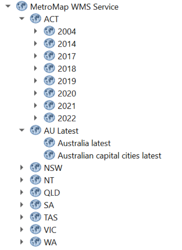
WMS Folder Structure
WMS supports managing large volumes of data layers by enabling a folder structure. The new MetroMap WMS will structure all our historic imagery layers by State, then Year to help users navigate through our growing list of data going back to 1943 in some locations.
The new WMS folder structure
WMS Version Support
1.1.1
Geographic Coordinate Systems specified with the EPSG namespace are defined to have an axis ordering of longitude/latitude
In the GetMap operation, the spatial reference system (SRS) parameter is called srs (examples below)
1.3.0
Geographic Coordinate Systems specified with the EPSG namespace are defined to have an axis ordering of latitude/longitude
In the GetMap operation, the spatial reference system (SRS) parameter is called crs (examples below)
Axis Ordering
1.1.1 always uses longitude/latitude (east/north) axis ordering
1.3.0 specification mandates using the axis ordering as defined in the EPSG database. For instance, for EPSG:4326 the axis ordering is latitude/longitude (north/east). But most spatial data is usually in longitude/latitude, or east/north
Examples:
1.1.1 ...VERSION=1.1.1&REQUEST=GetMap&SRS=epsg:4326&BBOX=-180,-90,180,90...
1.3.0 ...VERSION=1.3.0&REQUEST=GetMap&CRS=epsg:4326&BBOX=-90,-180,90,180...
Get imagery
Please be aware of the version's difference (bounding box, query parameter differences), and if PNG format is requested, the TRANSPARENT parameter needs to be set to true if the transparent channel is expected in the image and some parameters are not mandatory in the URL in order to get the image (see table at the end of the section)
1.1.1:
/ogc/key/{API-KEY}/service?LAYERS={LAYER}&FORMAT=image/{image format}&SRS=EPSG:{EPSG CODE}&EXCEPTIONS=application%2Fvnd.ogc.se_inimage&TRANSPARENT=TRUE&SERVICE=WMS&VERSION={version}&REQUEST=GetMap&STYLES=&BBOX={Bounding Box}&WIDTH={Width}&HEIGHT={Height}
1.3.0:
/ogc/key/{API-KEY}/service?LAYERS={LAYER}&FORMAT=image/{image format}&SRS=EPSG:{EPSG CODE}&EXCEPTIONS=application%2Fvnd.ogc.se_inimage&TRANSPARENT=TRUE&SERVICE=WMS&VERSION={version}&REQUEST=GetMap&STYLES=&BBOX={Bounding Box}&WIDTH={Width}&HEIGHT={Height}
Examples:
1.1.1
With system default parameters:
https://api.metromap.com.au/ogc/key/abcb7243-79d2-4411-a512-ee80c523adf6/service?SERVICE=WMS&VERSION=1.1.1&REQUEST=GetMap&BBOX=15985673.39343661442,-4512128.675878273323,15990980.91066532023,-4508049.848888013512&SRS=EPSG:3857&WIDTH=2000&HEIGHT=1537&LAYERS=Australia_latest&STYLES=&FORMAT=image/png&DPI=144&MAP_RESOLUTION=144&FORMAT_OPTIONS=dpi:144&TRANSPARENT=TRUE
With only mandatory parameters:
https://api.metromap.com.au/ogc/key/abcb7243-79d2-4411-a512-ee80c523adf6/service?SERVICE=WMS&VERSION=1.1.1&REQUEST=GetMap&BBOX=15985673.39343661442,-4512128.675878273323,15990980.91066532023,-4508049.848888013512&SRS=EPSG:3857&WIDTH=2000&HEIGHT=1537&LAYERS=Australia_latest&STYLES=&FORMAT=image/png&TRANSPARENT=TRUE
1.3.0
With system default parameters:
https://api.metromap.com.au/ogc/key/abcb7243-79d2-4411-a512-ee80c523adf6/service?SERVICE=WMS&VERSION=1.3.0&REQUEST=GetMap&BBOX=15985673.39343661442,-4512128.675878273323,15990980.91066532023,-4508049.848888013512&CRS=EPSG:3857&WIDTH=2000&HEIGHT=1537&LAYERS=Australia_latest&STYLES=&FORMAT=image/png&DPI=144&MAP_RESOLUTION=144&FORMAT_OPTIONS=dpi:144&TRANSPARENT=TRUE
With only mandatory parameters:
https://api.metromap.com.au/ogc/key/abcb7243-79d2-4411-a512-ee80c523adf6/service?SERVICE=WMS&VERSION=1.3.0&REQUEST=GetMap&BBOX=15985673.39343661442,-4512128.675878273323,15990980.91066532023,-4508049.848888013512&CRS=EPSG:3857&WIDTH=2000&HEIGHT=1537&LAYERS=Australia_latest&STYLES=&FORMAT=image/png&&TRANSPARENT=TRUE
Standard Parameters:
| Parameter | Required? | Description |
|---|---|---|
service | Yes | Service name. Value is WMS. |
version | Yes | Service version. Value is one of 1.0.0, 1.1.0, 1.1.1, 1.3.0. |
request | Yes | Operation name. Value is GetMap. |
layers | Yes | Layers to display on map. Value is a comma-separated list of layer names. |
styles | Yes | Styles in which layers are to be rendered. Value is a comma-separated list of style names, or empty if default styling is required. Style names may be empty in the list, to use default layer styling. |
srs or crs | Yes | Spatial Reference System for map output. Value is in form EPSG:nnn. crs is the parameter key used in WMS 1.3.0. |
bbox | Yes | Bounding box for map extent. Value is minx,miny,maxx,maxy in units of the SRS. |
width | Yes | Width of map output, in pixels. |
height | Yes | Height of map output, in pixels. |
format | Yes | Format for the map output. See WMS output formats for supported values. |
transparent | No | Whether the map background should be transparent. Values are true or false. Default is false. |
bgcolor | No | Background color for the map image. Value is in the form RRGGBB. Default is FFFFFF (white). |
exceptions | No | Format in which to report exceptions. Default value is application/vnd.ogc.se_xml. |
time | No | Time value or range for map data. See Time Support in GeoServer WMS for more information. |
sld | No | A URL referencing a StyledLayerDescriptor XML file which controls or enhances map layers and styling. |
sld_body | No | A URL-encoded StyledLayerDescriptor XML document which controls or enhances map layers and styling. |