- 04 Jul 2022
- 3 Minutes to read
- Print
- DarkLight
- PDF
Release 20220627: OGC Web Services (WMS/WMTS) Update
- Updated on 04 Jul 2022
- 3 Minutes to read
- Print
- DarkLight
- PDF
OGC Web Services (WMS/WMTS) Update
MetroMap's OGC web services have been improved and ehanced with new features
This includes significant backend improvements to performance and stability
There are also new features such as a Folder Structure and more Projection support for WMS only
The main online articles have been updated with new content where applicable
What's New?
API Key
The API Key has moved from query parametres to path parametres for both WMS and WMTS
/ogc/key/{api_key}/services?
MetroMap API will no longer support Username and Password. Users must have an API Key to access WMS/WMTS/XYZ
Image Formats
The new service will only provide PNG for tile services, but it will offer both JPEG and PNG for the WMS service.
PNG file size is slightly bigger than the JPEG file, but the quality is better, and it provides transparency
PNG
This format has transparency and RGB:

JPEG
This format only has RGB

Specific details are described below for each service
WMS Changes
- New Path
api-link/ path will be changed to:
ogc/key/{API-KEY}/service?REQUEST=GetCapabilities&SERVICE=WMS
NEW VERSION
https://api.metromap.com.au/ogc/key/abcb7243-79d2-4411-a512-ee80c523adf6/service?REQUEST=GetCapabilities
OLD VERSION
https://api.metromap.com.au/api-link/abcb7243-79d2-4411-a512-ee80c523adf6/wms?service=WMS&request=getcapabilities
Note: metromapkey/ path will not be supported:
metromapkey/wms?key={API-KEY}&service=WMS&request=getcapabilities
example:
https://api.metromap.com.au/metromapkey/wms?key=abcb7243-79d2-4411-a512-ee80c523adf6&SERVICE=WMS&REQUEST=GetCapabilities
- New Projection Support for GDA94 / SA Lambert
WMS supports multiple projections with 7-Parameter transformations. MetroMap has always supported all GDA94 and GDA2020 MGA Zones (plus others), we are now extending this to include other recognised and frequently used projection systems.
By popular request we have started offering GDA94 / SA Lambert. If you are a MetroMap Enterprise Subscriber, and you would like us to offer other EPSG Codes, please reach out to MetroMap Support
New EPSG Codes 4258 and 3107 added to GetCapabilities

- New Folder Structure
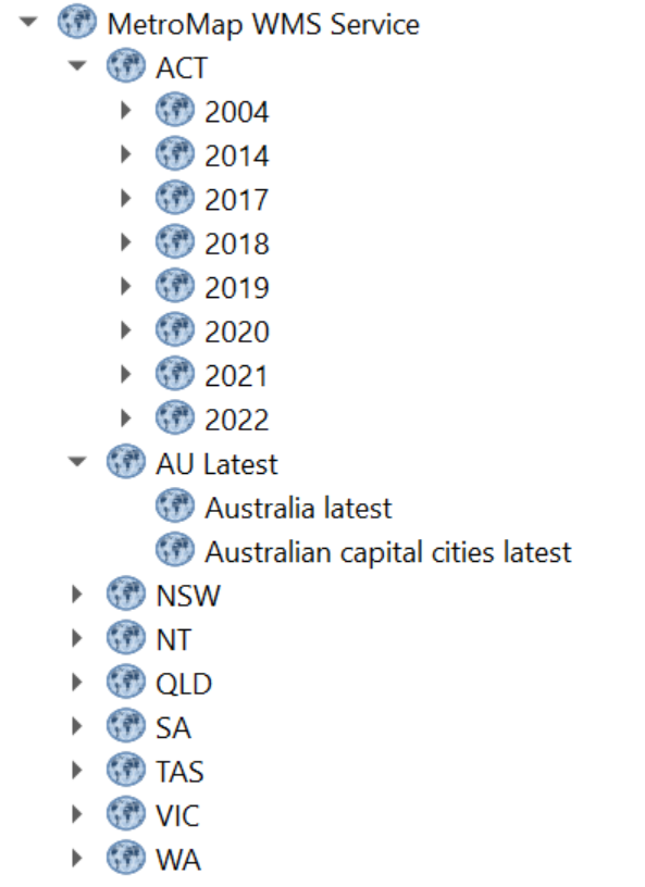
WMS supports managing large volumes of data layers by enabling a folder structure. The new MetroMap WMS will structure all our historic imagery layers by State, then Year to help users navigate through our growing list of data going back to 1943
The new WMS folder structure

Old WMS without folders

- New Version Support
1.1.1
geographic coordinate systems specified with the EPSG namespace are defined to have an axis ordering of longitude/latitude
In the GetMap operation, the spatial reference system (SRS) parameter is called srs (examples below)
1.3.0
geographic coordinate systems specified with the EPSG namespace are defined to have an axis ordering of latitude/longitude.
In the GetMap operation, the spatial reference system (SRS) parameter is called crs (examples below)
Axis Ordering
1.3.0 specification mandates using the axis ordering as defined in the EPSG database. For instance, for EPSG:4326 the axis ordering is latitude/longitude (north/east). But most spatial data is usually in longitude/latitude, or east/north
WMS 1.1 always uses longitude/latitude (east/north) axis ordering
Examples:
1.1.1
...VERSION=1.1.1&REQUEST=GetMap&SRS=epsg:4326&BBOX=-180,-90,180,90...
1.3.0
...VERSION=1.3.0&REQUEST=GetMap&CRS=epsg:4326&BBOX=-90,-180,90,180...
Get imagery
Please be aware of the version's difference (bounding box, query parameter differences), and if PNG format is requested, the TRANSPARENT parameter needs to be set to true if the transparent channel is expected in the image and some parameters are not mandatory in the URL in order to get the image (see table at the end of the section)
1.1.1:
/ogc/key/{API-KEY}/service?LAYERS={LAYER}&FORMAT=image/{image format}&SRS=EPSG:{EPSG CODE}&EXCEPTIONS=application%2Fvnd.ogc.se_inimage&TRANSPARENT=TRUE&SERVICE=WMS&VERSION={version}&REQUEST=GetMap&STYLES=&BBOX={Bounding Box}&WIDTH={Width}&HEIGHT={Height}
1.3.0:
/ogc/key/{API-KEY}/service?LAYERS={LAYER}&FORMAT=image/{image format}&SRS=EPSG:{EPSG CODE}&EXCEPTIONS=application%2Fvnd.ogc.se_inimage&TRANSPARENT=TRUE&SERVICE=WMS&VERSION={version}&REQUEST=GetMap&STYLES=&BBOX={Bounding Box}&WIDTH={Width}&HEIGHT={Height}
Examples:
1.1.1
With system default parameters:
https://api.metromap.com.au/ogc/key/abcb7243-79d2-4411-a512-ee80c523adf6/service?SERVICE=WMS&VERSION=1.1.1&REQUEST=GetMap&BBOX=15985673.39343661442,-4512128.675878273323,15990980.91066532023,-4508049.848888013512&SRS=EPSG:3857&WIDTH=2000&HEIGHT=1537&LAYERS=Australia_latest&STYLES=&FORMAT=image/png&DPI=144&MAP_RESOLUTION=144&FORMAT_OPTIONS=dpi:144&TRANSPARENT=TRUE
With only mandatory parameters:
https://api.metromap.com.au/ogc/key/abcb7243-79d2-4411-a512-ee80c523adf6/service?SERVICE=WMS&VERSION=1.1.1&REQUEST=GetMap&BBOX=15985673.39343661442,-4512128.675878273323,15990980.91066532023,-4508049.848888013512&SRS=EPSG:3857&WIDTH=2000&HEIGHT=1537&LAYERS=Australia_latest&STYLES=&FORMAT=image/png&TRANSPARENT=TRUE
1.3.0
With system default parameters:
https://api.metromap.com.au/ogc/key/abcb7243-79d2-4411-a512-ee80c523adf6/service?SERVICE=WMS&VERSION=1.3.0&REQUEST=GetMap&BBOX=15985673.39343661442,-4512128.675878273323,15990980.91066532023,-4508049.848888013512&CRS=EPSG:3857&WIDTH=2000&HEIGHT=1537&LAYERS=Australia_latest&STYLES=&FORMAT=image/png&DPI=144&MAP_RESOLUTION=144&FORMAT_OPTIONS=dpi:144&TRANSPARENT=TRUE
With only mandatory parameters:
https://api.metromap.com.au/ogc/key/abcb7243-79d2-4411-a512-ee80c523adf6/service?SERVICE=WMS&VERSION=1.3.0&REQUEST=GetMap&BBOX=15985673.39343661442,-4512128.675878273323,15990980.91066532023,-4508049.848888013512&CRS=EPSG:3857&WIDTH=2000&HEIGHT=1537&LAYERS=Australia_latest&STYLES=&FORMAT=image/png&&TRANSPARENT=TRUE
WMTS Changes
WMTS cannot support multiple projection systems or a folder structure, only a WMS can support these changes.
- New Path
api-link/ path will be changed to:
ogc/key/{API-KEY}/service?REQUEST=GetCapabilities&SERVICE=WMTS
NEW VERSION
https://api.metromap.com.au/ogc/key/abcb7243-79d2-4411-a512-ee80c523adf6/service?REQUEST=GetCapabilities&SERVICE=WMTS
OLD VERSION
https://api.metromap.com.au/api-link/abcb7243-79d2-4411-a512-ee80c523adf6/wmts?service=WMTS&request=getcapabilities
Note: metromapkey/ path will not be supported:
metromapkey/wmts?key={API-KEY}&service=WMS&request=getcapabilities
https://api.metromap.com.au/metromapkey/wmts?key=abcb7243-79d2-4411-a512-ee80c523adf6&SERVICE=WMTS&REQUEST=GetCapabilities
GetTiles (WMTS Only)
api-link/ path will be changed to:
/ogc/key/{API-KEY}/service?SERVICE=WMTS&REQUEST=GetTile&LAYER={LAYERS}&FORMAT=image/png&TileMatrixSet=webmercator&TileMatrix={Z}&TileRow={Y}&TileCol={X}&version=1.0.0&style={STYLES}
NEW VERSION
https://api.metromap.com.au/ogc/key/abcb7243-79d2-4411-a512-ee80c523adf6/service?SERVICE=WMTS&REQUEST=GetTile&VERSION=1.0.0&LAYER=Australia_latest&STYLE=default&FORMAT=image/png&TILEMATRIXSET=webmercator&TILEMATRIX=17&TILEROW=78928&TILECOL=116115
OLD VERSION
https://api.metromap.com.au/metromapkey/abcb7243-79d2-4411-a512-ee80c523adf6wmts/Australia_latest/default/GoogleMapsCompatibleExt:epsg:3857/17/78928/116115.webp
Note: metromapkey/ path will not be supported:
metromapkey/wmts?key={API-KEY}&SERVICE=WMTS&REQUEST=GetTile&LAYER={LAYERS}&FORMAT={image/FORMAT}&TileMatrixSet=webmercator&TileMatrix={Z}&TileRow={Y}&TileCol={X}&version=1.0.0&style={STYLES}


